Table of Contents
Solo hiking in the Canadian Rockies can be incredibly rewarding, especially if you choose well-traveled trails where route-finding is straightforward and you’re highly likely to meet other hikers throughout the day.
I realized there was real demand for solo-friendly hikes when a woman recognized me on Prairie Mountain in Kananaskis and told me she’d chosen the hike specifically because she knew it would be busy enough to feel comfortable hiking alone.
There are legitimate concerns related to solo hiking in the Canadian Rockies – bears, navigation, isolation, changing weather and the possibility of injury. I think about all these things when I hike alone and do my best to mitigate the risks. I make noise in bear country, keep bear spray accessible, choose trails with straightforward route-finding, and carry a Garmin inReach Mini 2 in case of an emergency.
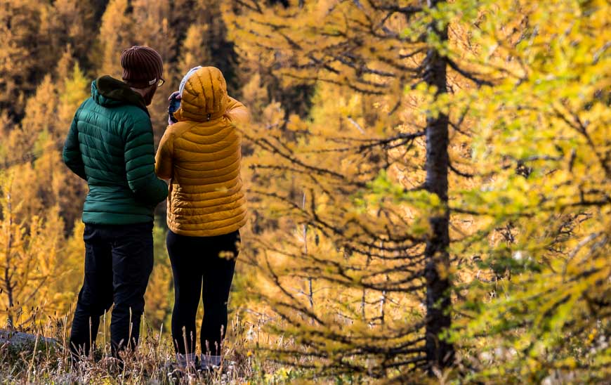
The hikes I’ve showcased in this guide see regular foot traffic especially between 10 AM and 4 PM in summer and fall. These are not remote wilderness hikes where you never see a soul. Instead, they are confidence-building hikes that offer gorgeous mountain scenery, on easy-to-follow trails. If you’re a solo hiker looking to exploring the Canadian Rockies, these trails will empower you.
This post includes some affiliate links. If you make a qualifying purchase through one of these links, I will receive a small percentage of the sale at no extra cost to you. I very much appreciate your support.
What Makes a Good Solo Hike in the Rockies?
- A popular trail
- Easy-to-follow with minimal route-finding on well-established paths
- Easy to moderate challenge
- Frequent hikers so you’re rarely alone
- No major creek crossings
- Safer shoulder-season options when there might be snow around
- Easy to bail-out if weather changes
- Obvious trailhead
- Fewer objective hazards
- Good summer trail conditions

Solo Hiking Tips for the Canadian Rockies
- Pack the 10 hiking essentials.
- Start early but not too early if you want people around.
- Carry easy to access bear spray and know how to use it.
- Ditch the bear bells. Your voice is better.
- Avoid wearing earbuds or headphones.
- Download offline maps.
- Tell someone your plans – what trail you’re hiking and when you’re due back.
- Know when to turn around.
- Choose busy trails for your first solo hikes.
- Bring hiking poles for steeper trails.
- Get a weather forecast beforehand. Weather changes quickly in the mountains.
- Don’t rely on cell service. Carry an emergency locator device like a Garmin inReach Mini 2 or a Zoleo Satellite Communicator.
When NOT to Hike Solo in the Canadian Rockies
There are times when solo hiking is really not a great idea. You will need to use your best judgement.
- Early season snow
- Exposed ridges – particularly in poor weather
- Remote trails with little traffic
- Shoulder season conditions
- Reports of recent bear sightings
- Poor weather forecasts
Great First Solo Hikes
- Troll Falls
- Johnston Canyon
- Bear’s Hump

Good for Building Confidence
- Chester Lake
- Sulphur Skyline
- Ptarmigan Cirque
Longer Solo Adventures with Regular Traffic
- Iceline Trail
- Plain of Six Glaciers
- Sulphur Skyline
- Prairie Mountain
- Crypt Lake

Location Map
Most of these hikes are accessible as day trips from Calgary, Canmore, Banff, Lake Louise, Jasper, or the Waterton townsite.
Best Solo Hikes in Kananaskis
Prairie Mountain
- Distance: ~6.6 km return
- Elevation gain: 726 m
- Time needed: 2.5 – 4 hours
- Difficulty: Hard
- Solo comfort level: High
- Likelihood of seeing other hikers: Very high
Solo Consideration
The hike up Prairie Mountain is a steep one, starting in forest and ending at the top of a broad rocky ridge offering both prairie and mountain views. The route is straightforward, but the climb is steep and sustained until you break out of the trees near the top. Then the wind can hit you! You’re rarely alone, especially on weekends. Conditions vary depending on the season. Take microspikes in spring, late fall and winter. Avoid hiking it when muddy in spring. It’s one of the premiere solo hikes near Calgary with easy accessibility off Highway 66.
Read the full Prairie Mountain hiking guide here.

Ha Ling Peak
- Distance: 7.8 km return
- Elevation gain: 810 m
- Time needed: 3 – 5 hours
- Difficulty: Hard
- Solo comfort level: Moderate
- Likelihood of seeing other hikers: Very high
Solo Consideration
The hike to Ha Ling Peak follows a steep, obvious trail that climbs quickly through forest before opening to a rocky alpine ridge with panoramic views over Canmore. The final section involves a steep set of stairs, and a final scree climb to the summit. Good footwear (microspikes in spring) and a favourable weather window are important. Even though it’s a very popular hike from early spring, through the summer and fall, it feels like a serious mountain climb for all.
Read the full Ha Ling Peak hiking guide here.

Chester Lake
- Distance: 9.0 km return
- Elevation Gain: 315 m
- Time Needed: 3 – 4 hours
- Difficulty: Easy to moderate
- Solo comfort level: High
- Likelihood of seeing other hikers: High
Solo Consideration
The Chester Lake hike follows a gentle to moderate trail through the forest to reach open meadows. From the meadows the grade moderates all the way to the lake. The trail is easy to follow and usually busy with hikers from July through October, especially during larch season. You can count on regular encounters with other hikers throughout the day.
Read the full Chester Lake hiking guide here.

Troll Falls + Marmot Falls
- Distance: 3.4 km return (Troll Falls), 4.3 km return (Marmot Falls)
- Elevation gain: 30 m (Troll Falls), 130 m (Marmot Falls)
- Time needed: 1.5 -2 hours
- Difficulty: Easy
- Solo comfort level: High
- Likelihood of seeing other hikers: Very high
Solo Consideration
The popular Troll Falls – Marmot Falls combination is a straightforward, easy hike through the trees to a couple of waterfalls. If you’ve got time, include a visit to pretty Marmot Falls and even Upper Troll Falls. Expect a crowded parking lot on weekends. In winter the hike to Marmot Falls is often closed because of icy conditions. Overall, this is a great option for solo hikers. I’ve always seen people on it, save for once when I did it as an evening hike.
Read the full Troll Falls hiking guide.

Ptarmigan Cirque
- Distance: 4.5 km return
- Elevation gain: 214 m
- Time needed: 1.5 – 2.5 hours
- Difficulty: Easy
- Solo comfort level: Moderate to high
- Likelihood of seeing other hikers: High
Solo Consideration
The Ptarmigan Cirque hike starts off with a steady climb but in no time the grade moderates and the trail continues to a wildflower-filled cirque with small waterfalls. The route is obvious and well-traveled, especially on summer weekends, when parking at Highwood Pass may be an issue. I’d recommend making noise on any quieter sections – and keep bear spray handy. Overall, it’s a strong choice for solo hikers especially on weekends with good weather.
Read the full Ptarmigan Cirque hiking guide.

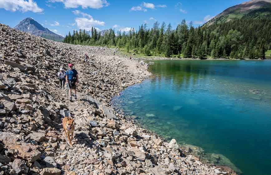
Rawson Lake
- Distance: 7.8 km return
- Elevation gain: 300 m
- Time needed: 2.5 – 3.5 hours
- Difficulty: Easy to moderate
- Solo comfort level: Moderate
- Likelihood of seeing other hikers: Moderate to very busy
Solo Consideration
The easy to moderate Rawson Lake hike can be done year-round. The trail follows the shore of Upper Kananaskis Lake before it starts climbing steadily through the forest to reach the lake. The hike is well-signed and route finding isn’t an issue. Expect steady foot traffic on weekends in summer, fall and winter. Weekdays are likely quieter. Conditions vary depending on the season. In winter I usually take microspikes or snowshoes, and in summer I’m prepared for mud. It’s an excellent choice for solo hikers, especially on weekends.
Read my full Rawson Lake hiking guide.

Wasootch Ridge
- Distance: 11 km return to the cairn
- Elevation gain: ~762 m
- Time needed: 4 – 6 hours
- Difficulty: Hard
- Solo comfort level: Moderate
- Likelihood of seeing other hikers: High on weekends
Solo Consideration
The Wasootch Ridge trail is a steep but fun lumpy ridge walk with ongoing elevation gain and loss, over its length. The easy-to-follow trail offers a steady climb with one short airy section above a small cliff that demands your attention. The trail is most popular from May (because it loses its snow early) to October, but it’s also a favourite of experienced hikers in the winter months. Carry hiking poles and microspikes if you plan to go when the trail is snow-covered. It’s a great choice for strong solo hikers looking for great scenery with a workout, especially on weekends when there are lots of hikers about.
Read my full Wasootch Ridge Trail guide here.

Best Solo Hikes in Banff National Park
Johnston Canyon
- Distance: 5.4 km return (Upper Falls)
- Elevation gain: 135 m
- Time needed: hours
- Difficulty: Easy
- Solo comfort level: Very high
- Likelihood of seeing other hikers: Very high
Solo Consideration
The easy, almost-always-busy Johnston Canyon trail follows Johnston Canyon up to two waterfalls via a fun hike that includes a cantilevered catwalk. The hike is straightforward with some gradual climbing. Expect crowds especially on weekends, so go early if you want a more peaceful experience. The canyon is open year-round, but in winter the trail is icy and microspikes are recommended. It’s a fantastic hike for solo travelers, especially with amazing canyon scenery along most of its length.
Read my guide to the Johnston Canyon here.

Tunnel Mountain
- Distance: 4.8 km return
- Elevation gain: 260 m
- Time needed: 2 hours
- Difficulty: Easy
- Solo comfort level: Very high
- Likelihood of seeing other hikers: Very high
Solo Consideration
The Tunnel Mountain hike is a gentle trail that weaves up through a forest with numerous scenic views out to the Banff townsite and Bow Valley. The trail to the Tunnel Mountain summit is well-signed and very easy to follow. Expect to encounter a steady stream of hikers, no matter what time of year you do it. In winter wear microspikes and consider taking hiking poles. It’s an excellent choice for solo hikers as its accessible on foot from the Banff townsite, the scenery is great, and you’ll run into people during daylight hours no matter what season you hike.
Read my guide to the Tunnel Mountain hike in Banff National Park.

Lake Agnes Tea House (+ Little Beehive, Big Beehive options)
- Distance: 7.0 km return
- Elevation gain: 396 m
- Time needed: 2.5 – 3 hours
- Difficulty: Easy
- Solo comfort level: Very high
- Likelihood of seeing other hikers: Very high
Solo Consideration
The hike to the Lake Agnes Tea House is one of the most popular hikes in Banff National Park, and an excellent choice for solo hikers. The easy-to-follow trail climbs steadily from Lake Louise via forested switchbacks to arrive at Mirror Lake. From there it’s only 0.8 km to reach Lake Agnes and the Tea House. At Lake Agnes you can continue to either Little Beehive or Big Beehive for panoramic views over Lake Louise and the surrounding mountains. Count on heavy foot traffic in summer and fall, especially by mid-morning. For many this will be a confidence-building solo hike with excellent scenery, easy navigation, and plenty of fellow hikers around. The crux of the hike is getting to the trailhead at Lake Louise.
Read my guide to the Lake Agnes Tea House hike or the Lake Agnes and Big Beehive hike.

Plain of Six Glaciers
- Distance: 13.8 km return
- Elevation gain: 380 m
- Time needed: 3 – 4.5 hours
- Difficulty: Easy
- Solo comfort level: High
- Likelihood of seeing other hikers: Very high
Solo Consideration
The Plain of Six Glaciers hike starts by Lake Louise and travels beside the lake and up into glacial moraines with ever more breathtaking views – especially of glaciers. From the end of Lake Louise, it’s a steady climb to the Plain of Six Glaciers Teahouse where you can eat lunch with a view. Expect company on the hike – though there will be short stretches when you may have the trail to yourself. It’s best hiked in the summer and early fall.
Read my guide to the Plain of Six Glaciers hike.

Sulphur Mountain
- Distance: 11 km return
- Elevation gain: 655 m
- Time needed: 2.5 – 4 hours
- Difficulty: Moderate
- Solo comfort level: Moderate to high
- Likelihood of seeing other hikers: High
Solo Consideration
The Sulphur Mountain hike in Banff National Park is a moderate trail that zigzags underneath the Banff Gondola through forest to finish at the gondola station. At the top there’s an option to hike to Sanson Peak via a scenic 600-metre-long boardwalk with spectacular Banff views. The trail is popular – especially in summer – and once at the top you can expect to see throngs of people. In winter, expect fewer hikers. Bring microspikes for the snow. The hike is rewarding without feeling remote. Banff public transit can drop you near the trailhead.
Read my guide to the Sulphur Mountain hike.

Larch Valley – Sentinel Pass
- Distance: 11.6 km return
- Elevation gain: 726 m
- Time needed: 4 – 5 hours
- Difficulty: Moderate
- Solo comfort level: High
- Likelihood of seeing other hikers: Very high
The hike to Larch Valley and Sentinel Pass is one of the busiest in the Canadian Rockies during larch season. The trail starts at Moraine Lake and climbs steadily via switchbacks through the forest before opening into gorgeous alpine meadows filled with golden larch trees in fall. The trail continues past Minnestimma Lakes, ultimately ending at Sentinel Pass. Count on very heavy foot traffic from mid-September through early October, with quieter but steady traffic in summer – so it’s a great choice for solo hikers. Parking and shuttle logistics can be more challenging than the hike itself, so planning on how to get to Moraine Lake is the crux of this hike.
Read my complete guide to the Larch Valley and Sentinel Pass hike.
Best Solo Hikes in Jasper National Park
Valley of the Five Lakes
- Distance: ~4.3 km return
- Elevation gain: 80 m
- Time needed: 1.5-2 hours
- Difficulty: Easy
- Solo comfort level: High
- Likelihood of seeing other hikers: High
Solo Consideration
The easy Valley of the Five Lakes hike is a family-friendly trail known for its turquoise lakes, forest loops, and fast access from the Jasper townsite. It’s set to reopen in summer 2026 – but I don’t know how it will look after the 2024 Jasper Fire. The loop hike should be straightforward – with well-placed red chairs at scenic spots beside the lakes. It’s always been a favourite year-round Jasper hike, and I expect it will be again. There may be some quieter sections along the trail, but in the past, there has always been steady foot traffic. In winter you may need microspikes or snowshoes.
Read my guide to the Valley of the Five Lakes hike.

Old Fort Point
- Distance: 3.8 km return
- Elevation gain: 130 m
- Time needed: 1.5 – 2 hours
- Difficulty: Easy
- Solo comfort level: High
- Likelihood of seeing other hikers: High
Solo Consideration
The Old Fort Point trail is a short out and back hike to a prominent hill of bedrock sitting above the Athabasca River. The route is straightforward and chances are high you’ll run into people along the way. In winter, wear microspikes as it’s often icy and snowy. The trail, with its proximity to Jasper, is ideal for solo hikers looking for a quick hiking fix with great views of the Jasper townsite.

Bald Hills
- Distance: 14 km return
- Elevation gain: 610 m
- Time needed: 4-6 hours
- Difficulty: Moderate
- Solo comfort level: Moderate to high
- Likelihood of seeing other hikers: High
Solo Consideration
The Bald Hills Trail is a moderate hike in Jasper National Park that takes you through forest and above treeline to a series of bald hills with sweeping views of Maligne Lake, the Opal Hills, and the Evelyn Creek Valley. It’s a popular hike so expect company – knowing that there will be stretches where you don’t see a soul. Give it a pass if there are thunderstorms forecast. It’s a great hike for solo hikers looking to build their confidence and at the same time experience one of the best hikes in Jasper National Park.
Read my guide to the Bald Hills hike.

Sulphur Skyline
- Distance: 8.0 km return
- Elevation gain: 700 m
- Time needed: 3-4 hours
- Difficulty: Moderate to difficult
- Solo comfort level: High
- Likelihood of seeing other hikers: High
Solo Consideration
The popular Sulphur Skyline Trail is a steep hike that starts beside Miette Hot Springs. The trail climbs on an obvious path through forest to a panoramic summit overlooking the Fiddle River Valley and surrounding ranges. Expect a steady stream of people, especially on summer weekends. Hike it from late spring to early fall – keeping an eye on the weather for summer storms. It’s an excellent and rewarding choice for solo hikers looking for a workout with fabulous mountain scenery.
Read my guide to the Sulphur Skyline Trail.

Best Solo Hikes in Yoho and Kootenay National Parks
Iceline Trail
- Distance: 13.6 km return (up to 21.1 km with loop options)
- Elevation gain: 690 m
- Time needed: 4 -6 hours (out and back version)
- Difficulty: Moderate
- Solo comfort level: High
- Likelihood of seeing other hikers: High to very high
Solo Consideration
The moderate Iceline Trail is one of the most scenic day hikes in Yoho National Park. Climb steeply from the parking lot to reach a world of glaciers, turquoise alpine lakes, and awe-inspiring views of Takakkaw Falls. The busy out and back hike is straightforward, but there are longer loop options that don’t see the same amount of foot traffic. It’s ideal as a summer or early fall hike. Solo travelers will love the accessibility (go early for parking), scenery, and trail camaraderie.
Read my guide to the Iceline Trail hike.

Emerald Lake Loop
- Distance: 5.2 km return
- Elevation gain: 50 m
- Time needed: 1 – 1.5 hours
- Difficulty: Easy
- Solo comfort level: High
- Likelihood of seeing other hikers: Very high
Solo Consideration
The easy Emerald Lake loop hike is another picturesque hike in Yoho National Park. The mostly flat well-maintained trail circles turquoise Emerald Lake, while offering up non-stop mountain views. While the route is straightforward and typically packed with people, the far side of Emerald Lake near the lodge is often quieter. Solo hikers should make noise through the high vegetation or join up with other hikers in this short section. The hike is especially pretty in fall. Come winter, beware of one large avalanche path that crosses the trail not far from the parking lot.
Read my guide to the Emerald Lake hike.

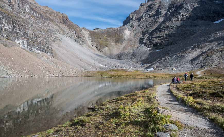
Stanley Glacier
- Distance: 8.8 km return + 4.4 km to the toe of the Stanley Glacier
- Elevation gain: 385 m – 820 m depending on how far you hike
- Time needed: 3 -4 hours for the regular route + ~2-3 hours if you go to the toe of the glacier
- Difficulty: Easy to the common turn around point; hard to the glacier
- Solo comfort level: High
- Likelihood of seeing other hikers: Very high
Solo Consideration
The Stanley Glacier trail winds through an old burn past the Guard Wall to finish at the end of a maintained trail overlooking a large rocky area containing Burgess shale fossils. While most hikers stop here, adventurous hikers can continue on a loop trail to the toe of the Stanley Glacier. The popular trail is easy to follow and well-traveled, especially on weekends. Solo hikers who are comfortable with quiet stretches will love the hike for the mountain scenery.
Read my guide to the Stanley Glacier hike.

Marble Canyon
- Distance: 1.6 km return
- Elevation gain: 30 m
- Time needed: 30 – 60 minutes
- Difficulty: Easy
- Solo comfort level: Very high
- Likelihood of seeing other hikers: High
Solo Consideration
Marble Canyon is a short and rewarding year-round hike that follows Tokumm Creek through a narrow limestone canyon via a series of bridges, each offering impressive views of the rushing turquoise water below. The final bridge provides the best view into the dramatic depths of Marble Canyon. This popular trail makes an excellent quick stop when driving between Radium Hot Springs and the Columbia Valley, and you’re rarely alone on the route. Exercise caution around bridges and railings when snow levels are high in winter.
Read my guide to the Marble Canyon hike.

Best Solo Hikes in Waterton Lakes National Park
Bear’s Hump
- Distance: 2.4 km return
- Elevation gain: 238 m
- Time needed: 60 – 75 minutes
- Difficulty: Easy
- Solo comfort level: High
- Likelihood of seeing other hikers: Very high
Solo Consideration
Bear’s Hump is a short, fun hike that climbs steadily through forest and open slopes to a panoramic viewpoint overlooking Upper Waterton Lake and the Waterton townsite. The trail is easy to follow, via a series of switchbacks that make the ascent feel more manageable than the elevation gain suggests. Look for hikers throughout the day from spring through fall, especially on weekends and summer afternoons. Strong winds are common at the summit, so bring an extra layer even on warm days. And don’t go too close to the edge. Overall, it’s an excellent choice for solo hikers looking for a quick hike with a big scenic payoff.
Read my guide to the best hikes in Waterton.

Lower Bertha Falls
- Distance: 5.2 km return
- Elevation gain: 175 m
- Time needed: 2 hours
- Difficulty: Easy
- Solo comfort level: Medium to high
- Likelihood of seeing other hikers: High
Solo Consideration
The hike to Lower Bertha Falls follows a well-traveled trail that starts near Cameron Falls at the Waterton townsite. It climbs gradually through burned forest to the scenic waterfall. The route is straightforward, and an excellent choice for hiking independently. Expect to see hikers throughout the day from late spring through fall, especially in summer. Stronger hikers can continue about 2.6 km past the falls to Bertha Lake for a 10.4 km round trip hike.

Crypt Lake (because it’s popular despite exposure)
- Distance: 17.4 km return
- Elevation gain: 690 m
- Time needed: 5 – 7 hours
- Difficulty: Moderate with exposed sections – a ladder, tunnel and cable climb
- Solo comfort level: High
- Likelihood of seeing other hikers: Very high
Solo Consideration
The moderate trail to Crypt Lake is an excellent choice for fit solo hikers who are looking for a mix of adventure and scenery – thanks to a short section that involves a ladder, tunnel, and chains. The hike starts and ends with a boat ride, so you can count on good foot traffic when the boat unloads. Even though hikers disperse, chances of seeing people for long stretches are very high. The boat runs from May 30 – October 12th, but the best time to go is in summer for the volume of hikers.
Read my guide to the Crypt Lake hike.

Red Rock Canyon Trail
- Distance: 0.6 km return
- Elevation gain: Minimal
- Time needed: 20 -30 minutes
- Difficulty: Easy
- Solo comfort level: Very high
- Likelihood of seeing other hikers: Very high
Solo Consideration
Red Rock Canyon is more like a scenic nature walk than a true hike, but it’s one of the most beautiful and accessible stops in Waterton. A short paved/ gravel loop takes you past red canyon walls and crystal-clear water, with lots of places to explore along the creek. There is heavy foot traffic all summer long so it’s an easy option for first-time solo hikers or anyone looking for a quick but rewarding outing between longer hikes. On hot days, I highly recommend soaking tired feet in the icy waters.

More Great Hikes & Backpacking Trips in the Canadian Rockies
Click on the photo to bookmark to your Pinterest boards.


